Seismographs
What are seismographs? Seismographs are used to locate the epicenter and to measure the strength of an earthquake. There are different types of seismographs. There are Horizontal (North,South), Horizontal (East,West), and Vertical. We need all three seismographs to measure the ground motion in 3-D.
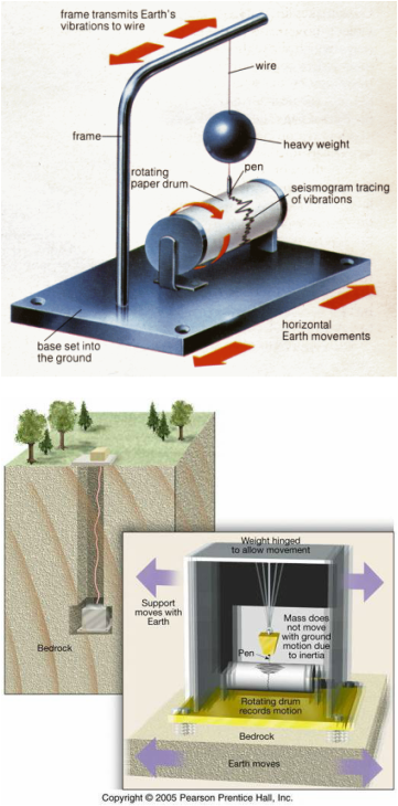
You can see in the picture on the left that there are various parts in a seismograph. The seismograph works based on the property of inertia. There is a pen that is hanging from a pendulum. While the earth is shaking, the rotating drum rotates, while the pen traces out the earth's vibrations on the seismogram.
When there is an earthquake, the ground shakes and the seismograph moves according to the movement of the ground. Notice that the pendulum inside is suspended and does not move with ground motion due to inertia (see picture on the lower left). This is the principle that allows the ground motion to be recorded on the rotating drum to produce a seismogram.
Locating the Epicenter
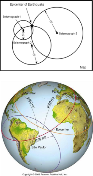
Seismologists locate the epicenter of an earthquake by means of triangulation. By measuring the difference between the arrival times of the P-waves and S- waves, the distance from the epicenter of an earthquake to the seismograph can be determined. This distance is represented by the radius of the circle in the figure on the right. Three different seismographs at different locations are required to determine the epicenter of an earthquake. The point where the edges of the three circles meet is the epicenter of the earthquake.
The picture on the lower left provides an example of how the epicenter of an earthquake in the middle of the Atlantic Ocean was determined. First, three seismograph stations in different parts of the world recorded the same seismic activities. In this case, seismograph stations in Montreal, Paris, and Sao Paulo recorded the earthquake on their seismograms. They then determined the distance from their respective stations to the epicenter. Lastly, by applying the triangulation technique described above the location of the epicenter was determined.
